
Read the plans
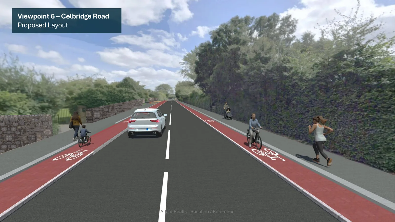
Everything is on the council's portal. The photomontages are the quickest way in — they show what the road would actually look like.
Consultation closes 5pm, Wed 5 Aug
Kildare County Council is planning an active travel scheme for the Celbridge Road — the road that serves two primary schools and that most parents won't let their children cycle on. It's a real improvement. We don't think it goes far enough. Until 5pm on Wednesday 5 August anyone can tell the council what they think, and the number of submissions matters.
Why this road
Two primary schools sit on this road. Plenty of the families who attend them live close enough to walk or cycle — and drive anyway, because the road doesn't feel safe enough to do otherwise. The result is a school run made of cars, on a road congested by the school run.
Ireland's own street design manual puts people on foot at the top of the pecking order, then people on bikes, then cars. This design still puts cars first. We support the scheme — we just don't think it is yet good enough to change how anyone travels.
Our position
We welcome the scheme. These are the changes we believe it needs — and you're welcome to use any of them in your own submission.
The scheme skips the stretch between the Rail Park and the Straffan Road, and no land purchase is needed to build it. A network is only as strong as its weakest link.
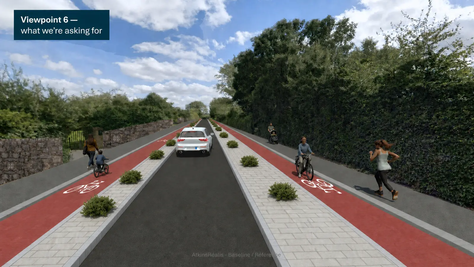
Along the open road, all that separates a child on a bike from passing traffic is a painted line and a low kerb. Good design is forgiving — a wobble shouldn't be fatal. There isn't room for a buffer everywhere, but there are stretches where there plainly is.
One: make the road one outbound lane between the Straffan Road and Griffin Rath, with the Griffin Rath road and the Eastern Ring Road taking the traffic. Two: make Laurence's Avenue a school street for inbound cyclists. Either frees the space.
At 3.15m each, the traffic lanes are 0.3m wider than the TII standard for a regional road. Wider lanes mean faster driving, and faster driving means worse injuries — beside two primary schools, that is the wrong way round.
Where the footpath and cycle track cross a side road, both should carry on across it, over entrance kerbs whose steep rise makes drivers slow. The National Transport Authority told councils to do this a decade ago. These drawings show none.
Shared space serves nobody well — people cycling at 16–20km/h beside people on foot leaves both uncomfortable. Wider, separate footpaths would make this road usable for the wheelchair and mobility-scooter users who avoid it today.
The council models traffic and costs when it builds a road; it should do the same here. H.E.A.T. is a free World Health Organisation tool used in more than seventy countries — and not yet in Kildare.
Three steps
It does not have to be long, formal or technical. Councils count and read every submission they receive, and a short one from a local resident counts the same as a long one.
Everything is on the council's portal. The photomontages are the quickest way in — they show what the road would actually look like.
A few honest sentences from a local resident carry real weight. Say where you live and how the road affects you. Personal experience persuades more than technical language.
Submit through the portal, quoting planning reference P82026.02. Late submissions cannot be considered, and submissions become part of the public planning record.
Part 8 — Proposed Celbridge Road Active Travel Scheme, Maynooth
Planning reference P82026.02 · Kildare County Council · Closes 5pm on Wednesday 5 August 2026
Consultation closed · 5 August 2026
Thank you to everyone in Maynooth who made a submission on the Celbridge Road Active Travel Scheme. Kildare County Council will now consider the submissions received before the scheme goes to elected members.
Our position
The scheme skips the stretch between the Rail Park and the Straffan Road, and no land purchase is needed to build it. A network is only as strong as its weakest link.
Along the open road, all that separates a child on a bike from passing traffic is a painted line and a low kerb. Good design is forgiving — a wobble shouldn't be fatal. There isn't room for a buffer everywhere, but there are stretches where there plainly is.
One: make the road one outbound lane between the Straffan Road and Griffin Rath, with the Griffin Rath road and the Eastern Ring Road taking the traffic. Two: make Laurence's Avenue a school street for inbound cyclists. Either frees the space.
At 3.15m each, the traffic lanes are 0.3m wider than the TII standard for a regional road. Wider lanes mean faster driving, and faster driving means worse injuries — beside two primary schools, that is the wrong way round.
Where the footpath and cycle track cross a side road, both should carry on across it, over entrance kerbs whose steep rise makes drivers slow. The National Transport Authority told councils to do this a decade ago. These drawings show none.
Shared space serves nobody well — people cycling at 16–20km/h beside people on foot leaves both uncomfortable. Wider, separate footpaths would make this road usable for the wheelchair and mobility-scooter users who avoid it today.
The council models traffic and costs when it builds a road; it should do the same here. H.E.A.T. is a free World Health Organisation tool used in more than seventy countries — and not yet in Kildare.
Every member makes us stronger when we ask for safer streets — and keeps us independent and locally funded. Membership starts at €30 a year.